Day 1: Saturday Windhoek – Mount Etjo Game Reserve – 230 km
You will be collected from your accommodation within the Windhoek city limits at 07:15 and transferred to Tour Headquarters for a short pre-departure meeting.
Heading north, we will make our first stop in the small town of Okahandja where we will find Namibia’s largest wood carving market. Craftsmen from all over Namibia come here to showcase a wide variety of items, both large and small. Here we have the opportunity to collect a truly Namibian souvenir and at the same time to support the local artists and communities.
Onwards to our overnight destination at Mt. Etjo campsite, which is located adjacent to the private Okonjati Game Reserve. After making camp and preparing lunch, we will drive the three kilometres to the lodge, where there will be time to explore the grounds and have a dip in the pool.
The lodge is built in an attractive Moroccan style, with red terracotta buildings and abundant palm trees and lawns. Around the lodge, and throughout the Okonjati reserve, rainwater dams have been built creating, after good rains, many large pools and small lakes. Around the main lodge area, the lake is extensive and supports a small population of hippopotamus. The habitat that these huge ‘water cows’ enjoy at the lodge is artificial, as hippos do not occur naturally in this semidesert region of Namibia. It does, however, offer us the privilege of perhaps seeing and photographing this iconic African species without having to travel many kilometres to the far north of Namibia.
Time for our first game drive, we meet our local guide and climb aboard open game viewing vehicles for our, about three hour, excursion into the reserve. The reserve is big 36,000 hectares, (nearly 90,000 acres), and it is as abundant in magnificent scenery as it is in wildlife. The overall terrain is dotted with truly huge copper red and grey termite mounds and is rich in native vegetation, dominated by Vachellia, (formally Acacia), thorn scrub and standing mopani trees. Okonjati reserve is largely free of invasive vegetation, thanks in part to the healthy appetites of the resident pachyderms and other shrub browsing species found here. This allows for areas of open and semi open grassland savanna, crisscrossed with many dry streams and riverbeds. Perfect for the game and perfect for us, as the open landscape makes game viewing and photography a pleasure.
We are hoping for Big Game, elephant and rhino in particular, but we are also watching out for giraffe and other, smaller species as well. Springbok, wildebeest, impala and kudu are numerous, but also mammals like warthog, steenbok and damara dik dik are all waiting to be spotted by sharp eyes. In the bush and around the seasonal waterholes, the game and birdlife is abundant.
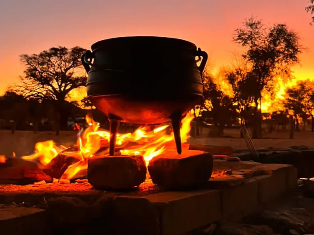
Not to be outdone by the wildlife, the scenery remains dominant. Pristine bush under the truly iconic African Big Sky’s and with a backdrop of towering red and grey sandstone massives. It doesn’t get much better than this. Around sunset, we will stop for some refreshments before returning to the lodge and then heading back to our campsite, and dinner tonight will be cooked by our guide over an open fire.
We are not done yet, though!
After dinner, we head back to the lodge to watch some of the resident lions enjoy their evening meal. These Big Cats are permanent residents at Mt. Etjo and have their own large secure enclosure where they live and where they can hunt naturally. From a secure hide that offers a close-up view, we can watch and photograph these magnificent cats as they arrive to enjoy the extra snack that is laid out for them.
From here we once again head back to our camp where we can, after a jam-packed day, finally settle down for our first night under canvas.
Accommodation: Twin share tents, shared ablution at campsite
Meals: Lunch & Dinner
Day 2: Sunday – Mount Etjo Game Reserve – Okaukuejo – Etosha National Park – 220 km
Departing after breakfast, we head back to the main road to continue our journey north, en-route to Etosha National Park. We make a short stop for essential supplies in the small town of Otjiwarongo before continuing on to Etosha’s main camp at Okaukuejo.
We are introduced to the park with a short game drive between the main entrance gate, (Anderson Gate), and Okaukuejo Camp with a good chance to spot big game right from the very start. Etosha is huge, just over 22,000 square km and is home to 114 species of mammal, 350 species of bird, 110 species of reptile, uncountable numbers of insects and, somewhat bizarrely, one species of fish.
After setting up our campsite, we will head out into Etosha searching for big game. Elephants, rhino, giraffes and the big cats are often seen in this area. We also look for the smaller species, several types of antelope and gazelle abound, zebra are common, and the bird life can be spectacular.
All visitors must be back in camp at sunset, but the ‘game show’ doesn’t stop when the sun goes down. Assessable on foot and only a short walk from our campsite, Okaukuejo is justly renowned for its flood lit waterhole where we are afforded the chance to see all of Etosha’s treasures. Big cats, elephants and the whole spectrum of smaller game, but in particular, this is our best chance of getting up close to a black rhino. Namibia is the last stronghold of these critically endangered creatures, but here, at Okaukuejo, they are regular visitors.
Accommodation: Twin share tents, shared ablution at campsite
Meals: Breakfast, Lunch & Dinner
Day 3: Monday – Okaukuejo – Halali – Okaukuejo – Etosha National Park
We have the whole day to explore Etosha, and we want to make the most of it. The park gates open at sunrise and after a quick cup of coffee and a snack we will aim to be on our way as the sun breaches the horizon. We head to the gate where we meet our local guide for today. We will explore Etosha with him and our guide on an open game viewer today. Early morning is usually a productive time for game viewing, and first thing in the morning is a good time to catch big cats returning from the hunt.
Etosha is a desert landscape and water is the most scarce natural resource. There are, however, numerous waterholes here, both natural and man-made, and our game driving technique is to take in as many as of these as possible. Here we hope that the game will come to us as the animals attend for an early morning drink. Along the way, we will make a stop at a designated picnic area for a quick breakfast before continuing our game drive en-route to the camp at Halali. The name for Halali is taken from a bugle refrain that was originally used during sport hunting with horse and hounds in Europe. The bugler would sound the Halali to signify that the hunt was over. This was considered appropriate for Etosha as inside the protection of the park, the hunting of animals is over forever.
We will have lunch at Halali. There is a small shop with basic merchandise and a few souvenirs, and there will also be time for a swim in the pool. There is also time to visit the Halali camp waterhole before we head back out into the park for our afternoon game drive.
On our way back to Okaukuejo we will stop to have a closer look at the Etosha Pan. The name Etosha translates as ‘great white space’ but this name does not do justice to the immensity of the pan. Over 4,700 square km of dazzling white mineral pan, so big that it can be seen from space.
Keeping a sharp look out for game as we wind our way back to Okaukuejo. We aim to arrive back at camp just before sunset and just in time for the best hour of the day at the Okaukuejo waterhole.
Accommodation: Twin share tents, shared ablution at campsite
Meals: Breakfast, Lunch & Dinner
Day 4: Tuesday – Okaukuejo – Palmwag – 320 km
Time to leave Etosha and concentrate on some of Namibia’s other highlights. We will have an early breakfast and game drive our way out of the park and back to the main road.
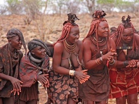
Our first stop of the day is a fascinating cultural visit, the Otjikandero Himba Village, located close to the small town of Kamanjab. The Himba people traditionally have their homeland in the very far north of Namibia in extremely remote yet beautiful areas. Because their communities were so isolated, the influence of the modern world took a little longer to reach these people, and they kept on living their traditional lifestyle much longer than did other ancient cultures. With the advent of tourism and the natural flow of change, many Himba have migrated further to the south, but traditions die hard and among all the other ethnic groups in Southern Africa, many Himba tribes people retain and live their traditions to this day.
The Otjikandero Himba Village is a living village, meaning that people live there on a permanent basis and largely adhere to their traditional cultures. It is not a time capsule, the 21st century has arrived here as well, but it is a good representation of traditional Himba life. We will be invited into the village, our visit will be guided, and we will be encouraged to take photos and ask questions, so there are no feelings of invading anyone’s privacy.
After our visit to Otjikandero we will have a short stop in Kamanjab before continuing on with our journey. The next leg of our journey today is truly spectacular, we turn to the west and head towards the mighty Etendeka Mountains and the Grootberg Pass.
Etendeka translates as ‘flat top’ and indeed many of the surrounding mountains have flat table-tops. The terrain here is covered with small uniform boulders, a legacy of the break-up of Gondwanaland when, what is now Southern Africa, broke away from what is now South America around 180 million years ago.
A time of massive volcanic upheaval and the same rocks, (Etendeka basalts), can be found in great abundance in Brazil. As we travel through this rocky landscape, we can enjoy the sweeping views and spectacular landscapes of this ancient land.
Palmwag is set out abreast of the Uniab River and under waving makalani palm trees, which often provide a refuge for Namibia’s unique desert adapted elephants. Sometimes coming very close to our camp, and sometimes coming right in for a visit, the elephants have been known to drink water from the swimming pools. We arrive in the late afternoon and set up our camp in time to enjoy a sundowner and hopefully see some of the resident elephant herds.
Accommodation: Twin share tents, shared ablution at campsite.
Meals: Breakfast, Lunch & Dinner
Day 5: Wednesday – Palmwag – Spitzkoppe – 420 km
We have reached the limit of our northern adventure, and today we first head west to the Atlantic Ocean and then directly south, following the coastline to Cape Cross and onwards to Spitzkoppe.
We set off through more beautiful scenery and passing many weird and wonderful species of vegetation that this area is famous for. In particular, we will see Namibia’s National plant, the wonderful and endemic Welwitschia Mirabilis. This species is, in fact, a dwarf tree and is found only in Namibia and southern Angola. The Welwitschia is a drought resistant superstar and almost as old as the landscape itself. Some specimens are known to be over 1,500 years old.
We enter the Skeleton Coast National Park through the northern Springbokwasser Gate, and soon afterwards we meet the chilly Atlantic Ocean. It is easy to see why this barren seaboard is called the Skeleton Coast, with its forbidding mountains and barren beaches. The wind, the waves and the huge fog banks all conspire to push ships onto the beach. The countless mariners that, in olden times, found themselves shipwrecked here faced the stark prospect of no fresh water, no food, no rescue and a slow death by exposure. Their Shipmates who went down with their ship were thought to be the lucky ones. There are some remnants of human activity along our road today. In the early 1960s, two pioneering entrepreneurs, Jack Scott and Ben du Preez found themselves convinced that both oil and diamonds were to be discovered along the Skeleton Coast and that this was their chance at fame and fortune. At huge expense a massive drilling rig was set up and managed a bore of 1,700 meters before they could finally admit that there was no oil.
Not daunted and encouraged by reports of huge diamonds at Cape Cross, the same pair constructed a diamond mine and processing plant at Toscanini, close to where their abandoned oil rig was already rusting away. Some diamonds were ‘found’ but there was great suspicion that the diamond processor had been ‘seeded’ with diamonds from elsewhere. A ploy to keep the investors happy for a little bit longer. Both enterprises ended in failure, but we will pass by Toscanini, and we can stop and have a look at the now collapsed oil drilling machine.
Exiting the park at the Ugab River crossing with its Instagram worthy iconic gates, we continue onto one of the largest seal colonies in the world. Nobody knows exactly why the seals chose Cape Cross as their home, but there must be a good reason, as there are usually upwards of 100,000 seals basking on the rocks or swimming just off the beach. These Cape fur seals are found only in South Africa, Namibia and Angola and are near endemic to Namibia. Cape Cross is the largest Cape fur seal colony in the world, but there are many smaller colonies also to be found on the Namibian beaches, and the Namibian Skeleton Coast hosts by far the majority of the world’s population. Cape Cross is an outstanding sight, and a challenge for your nose, the smelliest stop on our safari.
Cape Cross takes its name from the stone crosses that proudly sit close to the seal colony. The first cross to be erected here was done so on the orders of the Portuguese mariner Diogo Cão in 1485. In those days, the cross would have been called a ‘Padrao’ and the location was thus named Cabo do Padrao or Cape Cross. The original cross is in a museum in Germany and the two crosses visible today are replicas, erected respectively by the German government and the monuments’ council of South Africa. The concrete discs set around the two replica crosses are, in fact, set out to represent the stars of the southern cross. A tribute to the navigational skills of the tough breed of men who made the first voyages of discovery. Diogo Cão never made it home to Portugal from this voyage, and his death is shrouded in mystery.
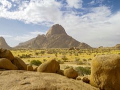
We continue back inland to the magnificent Spitzkoppe Mountain. These granite mountains stand out on the gravel plains and are renowned for great sunset and sunrise moments, as well as for night photography. After setting up camp, we go into the mountains for sunset before returning to camp for dinner.
Accommodation: Twin share tents, shared ablution at campsite.
Meals: Breakfast, Lunch & Dinner
Day 6: Thursday – Spitzkoppe – Swakopmund – Hotel A La Mer Swakopmund
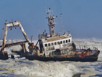
After breakfast and breaking camp, we head back to the coast and then south along the coast to the adventure capital of Namibia, Swakopmund. Heading south on the coast road, our first stop is a more recent shipwreck. 15 km south of the small town of Henties Bay, a fishing trawler, The Zeila, was beached in 2008. She was an old vessel that had been sold for scrap and was under tow at the time. The cable snapped and, as so many vessels before her, she was caught in the swell and currents and ended up on the beach. She lays quite close to the shore and is well positioned for photos.
Continuing south along the coast road, there is another interesting stop to make before we arrive in Swakopmund. Namibia is home to a world-record number of lichen, and along the coast here we find vast lichen fields. Examples such as we have here, of this nature and scale, are very rare around the world.
Lichen often look like plants and do to some degree function like plants, but they are not a plant and can be well described as a composite organism. The lichen we find in such abundance along the Skeleton Coast are called macro-lichen, which typically refers to lichen that are bush like or leafy.
The curious thing about lichen is that it is made up of two separate organisms, algae and fungi. Neither organism would be able to survive in this environment on its own, (separate them, and they will both die), but together they form a symbiotic relationship within which both can thrive. The fungi are responsible for collecting the moisture that they both use, and the algae is responsible for the food. Unlike plants, lichen have no roots, but like plants, lichen do perform photosynthesis, or rather the algae part of the lichen, which is green, performs photosynthesis. The chemical sugars produced by this process keeps both fungi and algae well-fed. It seldomly rains on the Skeleton Coast, but the region is famed for its foggy weather. Heavy mist is common, occurring up to 250 days of the year, and all the organisms, including lichen, that survive on the Skeleton Coast are specially adapted to be able to utilise fog as their main source of water. Lichen is extremely fragile. Typically, with a growth rate of around 1 millimetre per year and it is effortlessly damaged. Off-road driving is a major problem for the conservation of these unique lichen fields, but a lot of damage is also done simply by people walking on the lichen. Our guide will direct us as to where we are allowed to walk as he introduces us to the lichen fields, and great care must be taken that we do not inadvertently cause any damage during our visit.
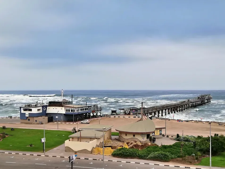
We complete the final leg of our journey into Swakopmund, no tents tonight we check into our accommodation, the centrally located Hotel A La Mer Swakopmund was founded by Captain Kurt von François of the imperial colonial army of the German Empire in 1892. (He also founded Windhoek in 1890).
Swakopmund is an interesting place to say the least, bound to the north, the east and the south by the mighty sand dunes of the Namib Desert and to the west by the Atlantic Ocean. There are still many examples of colonial German architecture to be seen, and the German language is still widely used.
Swakopmund offers many opportunities to keep us busy during our time here. The town centre is small and easily explored on foot, but there are also many extra, optional activities available. Scenic flights over the desert are very popular, and for the more adventurous, perhaps try skydiving or quad biking over and in the Namib dunes. Our guide will discuss all the options with you in advance and will be able to facilitate any bookings that we would like to make. For the more leisurely minded, there are bicycle tours and the very popular ‘living desert’ excursions. Here you will join a group in a vehicle with a specialist guide who will take you into the sand dunes sea and introduce you to some of the wonderful creatures and plants that survive in one of the toughest environments in the world.
Lunch and dinner tonight are for your own account, Swakopmund boasts some truly excellent restaurants and again, our guide will be able to help you with recommendations and bookings.
Accommodation: Twin share rooms, en-suite bathroom
Meals: Breakfast
Day 7: Friday – Swakopmund – Sesriem – 350 km
Making the most of our time at the coast, we only leave Swakopmund this morning at 11:30, giving us plenty of time to wander around town. Alternatively, there are many more optional activities available this morning if you wish.
For those with a love of adrenaline, sand boarding is also a very popular if you fancy careering down the slip face of a sand dune at 60 km per hour. This activity is generally only available in the morning.
Departing Swakopmund no later than 11:30, we head east into the desert. We first cross the Namib gravel plains, large areas of flat and seemingly barren terrain broken up by huge mountain inselbergs. We have two mountain passes to traverse this afternoon, the first is the mighty Kuiseb Pass, and we follow the road from the top of the mountains, dropping steeply down into the canyon carved over eons by the Kuiseb River on its way to debouch into the ocean at the port town of Walvis Bay. We climb up from the banks of the river and over the pass, travelling through the mountain peaks and on to the second, smaller canyon of the Gaub River, a tributary of the Kuiseb. We emerge from the mountains onto a flat road, and almost immediately we cross the Tropic of Capricorn at 23.5 south degrees. There is a signpost at this auspicious spot, and we stop along the road for photos.
From here we continue on through the desert landscape to the tiny town of Solitaire where we can stretch our legs and sample the apple pie that has made this homestead famous. Onwards again to our destination for today, the gateway to the dunes and Sossusvlei at Sesriem.
We make our campsite, anticipating our day tomorrow, in the shadow of the towering red dunes of the world’s oldest desert
Accommodation: Twin share tents, shared ablution at campsite.
Meals: Breakfast, Lunch & Dinner
Day 8: Saturday – Sesriem – Sossusvlei – Sesriem – 120 km
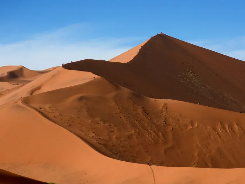
Sunrise in the dunes is the name of the game this morning, and that means a pre-dawn start. Our first stop will be at Dune 45, so named because it is 45 km from Sesriem, and we cover this first distance in darkness and early morning twilight.
The best time to photograph the dunes is around sunrise and sunset. This is when you can see towering sand dunes illuminated a glowing orange, apricot red on one side and swathed in shadow on the other. The depth of field is spectacular at this time of day.
We arrive at Dune 45 and climb to a vantage point for sunrise, watching as the colours grow and change with the ever-altering light. Back to the vehicle for a quick breakfast, and we carry on for the last few kilometres to the 2×4 car park, where we board the 4×4 shuttle vehicles into the vlei. From here we enter the ancient Tsauchab River-bed for the last 5km leg to Sossusvlei itself. The Tsauchab River is ephemeral, it only flows seasonally, when there is enough rain, and for the most part, the river-bed is dry. Eons ago, during these rare floods, the Tsauchab sometimes received enough water to flow all the way to the Atlantic Ocean. However, as the millennia passed and the dune fields began to form, (around five million years ago), wind -blown sand invaded the river-beds. The rivers became more and more constricted by sand, until eventually the occasional floods could not break through the sand barriers that had been erected by the wind. The valley we drove along this morning in the darkness is kept free of sand by the Tsauchab Sossusvlei is now permanently water’s end.
Sossusvlei does still sometimes flood, (perhaps once in a decade). After good rains in the Naukluft Mountains where the river rises, Sossusvlei can become inundated, and the lake that this creates can last for many months, but no longer can the river find its original path to the Atlantic.
The 4×4 shuttle service will transport us through the sandy terrain of the river-bed. We will visit Dead Vlei on foot led by our guide, an ancient pan surrounded by sand, that is strikingly populated with dead, skeletal camel thorn trees. These trees have been a feature of this landscape for over 1000 years. Sossusvlei is almost surrounded by dunes, just one narrow path kept open by the Tsauchab River. We have time to explore the area on foot and to climb one of the highest dunes in the world, some towering 300 m above us, the views are breathtaking and justly famous.
We drive back to Sesriem for lunch and perhaps a dip in the swimming pool, and in the afternoon we take a short excursion to see the Sesriem Canyon.Only four km from our campsite, this canyon has been carved out of the landscape by the Tsauchab River. Around two million years ago, there was an ice age in Europe. This caused glaciers to form and resulted in a worldwide drop in sea level. The knock on effect of this at Sesriem Canyon was that it increased the length and water flow of the Tsauchab River. This greater force of water allowed the Tsauchab to begin cutting through the terrain, resulting in the canyon we can see today. We can easily walk into the river-bed, it is usually much cooler in the canyon, and we can follow the river for some way along its journey to Sossusvlei.
In the late afternoon there is one further option with which to close our time in the world’s oldest desert. A short drive will take us to Elim Dune, for the best golden light before sunset. From here, if you would like to, it is a relatively short walk back, through the desert, to our camp.
Accommodation: Twin share tents, shared ablution at campsite
Meals: Breakfast, Lunch, Dinner
Day 9: Sunday – Sesriem – Klein Aus Vista – 350 km
We have a scenic drive today through ever-changing desert scenery, mountains and open grassland. We are continuing our long drive south and our destination is the tiny community of Aus, located in the Aus Mountains above the plains of the Namib Desert.
Aus was formally the site of a prisoner of war camp set up by the South African army to house German prisoners during the second world war.Our actual destination today is Klein Aus Vista, located just outside Aus and just inside the private Gondwana Sperrgebiet Rand Park. We aim to arrive in the early afternoon and set up camp, giving us time to stretch our legs on the unguided hiking trails on the property.
The landscape is wide open vistas, and we are hoping for a spectacular sunset.
Accommodation: Twin share tents, shared ablution at campsite
Meals: Breakfast, Lunch, Dinner
Day 10: Monday – Klein Aus Vista – Luderitz – Klein Aus Vista – 250 km
We again start early but with the luxury of a proper sealed tar road today. We travel through grasslands and wide open desert scenery on our easy drive towards the ocean.
Desert adapted horses run wild in this area, and we need to keep a good look out for these remarkable creatures. Horses are not a part of the true desert ecosystem, and their origins here remain open to speculation. Perhaps they are descended from the German cavalry lines during the first world war. It is also documented that Hans Heinrich von Wolf, owner and resident of Castle Duwisib in 1909, was a keen horse breeder. Maybe the origins of the horses today come from his blood stock escaping their stables at Duwisib. Whatever their true history, it is a privilege to see these animals in their wild habitat.
We are en-route to the ghost town of Kolmanskop, located about 15 km from the port town of Luderitz. For centuries, among early mariners, there have been rumours and stories of untold riches to be found on one far-flung coast or another. Most often these claims turned out to be just stories, but in the case of the far south-west of Namibia, it happened to be true. When diamonds were first discovered here, you could literally walk along the beach and fill your pockets with these precious stones. The first diamond mine was called Kolmanskop. Founded in 1908, it was built in the architectural style of a German village and was supplied with the most modern amenities of the age. There was a hospital that boasted the first x-ray machine in the Southern Hemisphere, a power station, a school, a ballroom and an ice factory. The decline of Kolmanskop started around 1920 when the diamonds began to run out. Then in 1928, the richest diamond deposits that the world had, at the time, ever known were discovered 270 km away to the south at the Orange River. Kolmanskop became deserted and so started the slow reclamation of the town by the desert. Still a striking sight today, we will stop at Kolmanskop for a guided tour of the town and the opportunity to photograph this unique and interesting site.
On departure from Kolmanskop we quickly cover the last few kilometres to Luderitz itself, well known for its unique and colourful colonial-style buildings. We drive out on to the Luderitz peninsula and enjoy the scenery on the way to the historical monument at Diaz Point. As at Cape Cross, the first sign of European interest in this land was from the Portuguese, and in this case, it was the navigator Bartolomeu Diaz who landed here in 1487 and caused a stone cross to be erected. This time the name given to the area was Angra das Voltas or ‘Bay of Tacks’ about the many times Diaz had to ‘tack’ his ship against the southern gales. Luderitz is still today one of the windiest places on planet earth, so some things at least have not changed over the centuries.
We head back to our accommodation at Klein Aus Vista, taking a second opportunity to see the desert horses and arriving in time for a sundowner at Klein Aus Vista.
Accommodation: Twin share tents, shared ablution at campsite
Meals: Breakfast, Lunch & Dinner
Day 11: Tuesday – Klein Aus Vista – Quiver Tree – 550 km
A long drive today, but we take advantage of the tar road for the first part of the morning. We are heading east, but we will soon turn south again to complete our traverse of Namibia’s southern region. Our first main stop this morning will be the incredible Fish River Canyon located in the /Ai-/Ais Richtersveldt Transfrontier National Park. We enter the park at the Hobas gate, and from there it is only a short drive to the main lookout point over the Fish River Canyon.
Second only in size to the Grand Canyon in Arizona, the vistas across this most immense of nature’s sculptures are breathtaking. From our vantage point high up on the plateau we overlook the so called ‘Hell’s Bend’ which takes the form of a huge meander along the course of the Fish River. The canyon itself is around 160 km long, 27 km wide at its widest point and in places 550 m deep. The origins of the Fish River Canyon can be traced back to about 1,800 million years, and the formation of the canyon itself can be attributed to just about every possible geological force known to man. Huge seismic forces, volcanic eruptions, earthquakes, glacial activity, relentless erosion of every kind and finally, deepened by the Fish River that we can see glinting in the sunlight far below us. This is a perfect example of tortured rock that inspires our awe by its sheer massive size.
It is difficult to leave such an impressive sight, but we journey onwards, turning our heads to once again to the north as the canyon marks the end of the southern leg of our trip. We are en-route to Keetmanshoop, the main commercial and political centre of Namibia’s south. A short stop here and then on to our overnight camp at the Quiver Tree Forrest. Quiver trees are Namibia’s National Tree and are so named because the San tribes of Southern Africa used to strip the scaly bark from these trees and construct from it a narrow cylinder. From this, they would manufacture a quiver in which to keep their poisoned arrows. A quiver tree, despite its very tree like appearance, is, in fact, not a tree at all. Its real name is Aloidendron Dichotomum, (formally Aloe Dichotoma), and so is an aloe, and an aloe is a plant and not a tree. This does not diminish the impact they have on the landscape, weird and wonderful shapes abound from this collection of around 250 quiver plants/trees/aloes?
The oldest specimens here are estimated to be about 200 years old, and it is thought that they can achieve an age of up to 300 years. Dating a quiver tree, however, is difficult, as it does not have rings of bark to count, the centre of the tree is fibrous and there is really no established method of ageing.
The campsite tonight is a rustic camp, but we have the great benefit that is within the Quiver Tree fores. This allows for a stunning sunset as well as the opportunity for some night photography. This is the last night of our safari and time to reflect on our amazing adventure as we sit around our camp-fire one last time.
Accommodation: Twin share tents, shared ablution at campsite
Meals: Breakfast, Lunch, Dinner
Day 12: Wednesday Quiver Tree Forrest – Windhoek 500 km
We head north today, and we have the luxury of the main tar road for our whole journey, no gravel road ‘African Massage ’to contend with, as we head back to Windhoek. Namibia is so rich in interesting things that it is impossible to drive for any great distance without passing places of interest, and there are several worth mentioning along the way today.
After about 80 km from Keetmanshoop, in the distance and off to the west, we can see a tall mountain peak. This is Brukkaros, another volcano but quite an unusual one. Brukkaros was formed around 180 million years ago when molten magma from deep below the surface was pushed upwards until it intruded into the overlaying, relatively soft, sedimentary formations that made up the surface. Molten magma intrusions are common in world-wide geology, but what makes Brukkaros unusual is that in this case the upward moving magma hit an underground lake, leading to a huge explosion powered by super-heated steam.
What was left formed a hollow cave, that was once the magma chamber, but with an overhead ‘caldera’ forming a partial roof. 80 million years later, the weight of the caldera was too much and collapsed into the magma cave. Brukkaros is 1,590 m tall at its highest point, the collapsed caldera measures about 4 km in diameter. The mountain itself is 650m higher than anything else in the area, and the crater floor is 350 m below the rim. Steam formed volcanoes are very rare, and although Brukkaros is too far away to be included on this itinerary, it is an interesting landmark to look out for on our drive today.
About 150 km into our long road today, we will pass a signpost to a place called Gibeon. Again, like Brukkaros, Gibeon is too far away to be included in this itinerary, but there is an interesting story that is worth telling. Near here, in ancient prehistoric times, the area around what is now Gibeon was subjected to a Meteor strike of very significant proportions. The meteor, when intact, was thought to measure 4 x 4 x 3 meters, and we know that it was made of solid metal. As it entered the earth’s atmosphere, the metal began to melt and in due course the meteor fragmented in a huge explosion, scattering chunks of molten metal across the countryside. Meteor’s from this event have been found as far away as Brukkaros Volcano to the south and as far away again towards the north, but the greatest concentration of meteor material has been found in and around Gibeon.
If you have time in Windhoek after our safari it is worth going to Post Street Mall in the city centre where you will find a public display of Gibeon Meteorites
Still heading ever north, our journey today takes us through the small centres of Mariental and Rehoboth, and we will stop along the road today for a light lunch. We aim to be back in Windhoek in the late afternoon.
There will be a shuttle service to take you to your accommodation within the Windhoek City limits.
We recommend that departure flights are not scheduled for today.
Accommodation: None
Meals: Breakfast, Lunch